Geolocate

Hemkund topographic map

Click on the map to display elevation.

About this map

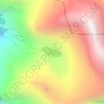
Name: Hemkund topographic map, elevation, terrain.

Location: Hemkund, Joshimath Tehsil, Chamoli, Uttarakhand, India (30.69735 79.61546 30.70015 79.62149)

Average elevation: 4,367 m

Minimum elevation: 3,475 m

Maximum elevation: 5,094 m

Other topographic maps

Click on a map to view its topography, its elevation and its terrain.

Kamet

India > Uttarakhand > Joshimath Tehsil

Average elevation: 6,701 m

Trisul I

India > Uttarakhand > Joshimath Tehsil

Average elevation: 6,343 m

Pangarchulla

India > Uttarakhand > Joshimath Tehsil

Average elevation: 4,061 m

Auli

India > Uttarakhand > Joshimath Tehsil

Average elevation: 2,438 m

Badrinath

India > Uttarakhand > Joshimath Tehsil

Average elevation: 4,052 m

Nanda Devi

India > Uttarakhand > Joshimath Tehsil

Average elevation: 6,567 m

Urgam

India > Uttarakhand > Joshimath Tehsil

Average elevation: 2,351 m

Badrinath

India > Uttarakhand > Joshimath Tehsil

Average elevation: 4,052 m

Nanda Devi

India > Uttarakhand > Joshimath Tehsil

Average elevation: 6,567 m

Chain

India > Uttarakhand > Joshimath Tehsil

Average elevation: 2,031 m

Malari

India > Uttarakhand > Joshimath Tehsil

Average elevation: 3,458 m

Saraswati

India > Uttarakhand > Joshimath Tehsil > Mana

Average elevation: 5,393 m

Malari

India > Uttarakhand > Joshimath Tehsil

Average elevation: 3,458 m

Tugasi

India > Uttarakhand > Joshimath Tehsil

Average elevation: 2,785 m

Dhak

India > Uttarakhand > Joshimath Tehsil

Average elevation: 2,373 m

Nanda Devi

India > Uttarakhand > Joshimath Tehsil

Average elevation: 6,567 m

Dunagiri

India > Uttarakhand > Joshimath Tehsil

Average elevation: 6,059 m

Joshimath

India > Uttarakhand > Joshimath Tehsil

Average elevation: 2,272 m

Garpak

India > Uttarakhand > Joshimath Tehsil

Average elevation: 3,646 m

Tapoban

India > Uttarakhand > Joshimath Tehsil

Average elevation: 2,287 m

Bamba

India > Uttarakhand > Joshimath Tehsil > Pharkia

Average elevation: 3,731 m

Badrinath

India > Uttarakhand > Joshimath Tehsil

Average elevation: 4,052 m