
Thank you for supporting this site ❤️
Make a donation
Make a donation
Beirã topographic map
Click on the map to display elevation.
Thank you for supporting this site ❤️
Make a donation
Make a donation
About this map
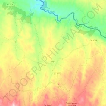
Name: Beirã topographic map, elevation, terrain.
Location: Beirã, Marvão, Portalegre, Portugal (39.41641 -7.41479 39.49527 -7.30497)
Average elevation: 391 m
Minimum elevation: 198 m
Maximum elevation: 596 m
Thank you for supporting this site ❤️
Make a donation
Make a donation
Other topographic maps
Click on a map to view its topography, its elevation and its terrain.