
Thank you for supporting this site ❤️
Make a donation
Make a donation
Pleasant Grove topographic map
Click on the map to display elevation.
Thank you for supporting this site ❤️
Make a donation
Make a donation
About this map
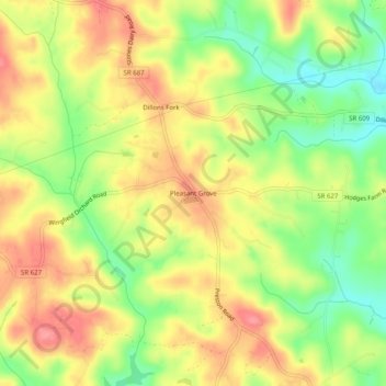
Name: Pleasant Grove topographic map, elevation, terrain.
Location: Pleasant Grove, Henry County, Virginia, 24089, United States (36.66680 -80.02199 36.70680 -79.98199)
Average elevation: 297 m
Minimum elevation: 250 m
Maximum elevation: 337 m
Thank you for supporting this site ❤️
Make a donation
Make a donation
Other topographic maps
Click on a map to view its topography, its elevation and its terrain.