
Make a donation
Feldberg topographic map
Click on the map to display elevation.
Make a donation
Feldberg
Feldberg is a municipality in the district of Breisgau-Hochschwarzwald in Baden-Württemberg in southern Germany. It is located near the Feldberg, the highest summit in Baden-Württemberg. It comprises the settlements of Altglashütten, Neuglashütten, Falkau, Bärental, and Feldberg. At an elevation of 1,277 m, the last is considered the highest village in Germany.
Make a donation
About this map
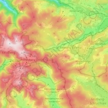
Name: Feldberg topographic map, elevation, terrain.
Average elevation: 1,037 m
Minimum elevation: 709 m
Maximum elevation: 1,448 m
Make a donation
Other topographic maps
Click on a map to view its topography, its elevation and its terrain.
Dietenbach
Germany > Baden-Württemberg > Landkreis Breisgau-Hochschwarzwald > Kirchzarten (Kernort) > Kirchzarten
Average elevation: 482 m
Rheintal
Germany > Baden-Württemberg > Landkreis Breisgau-Hochschwarzwald > Müllheim im Markgräflerland
Average elevation: 424 m
Make a donation
Wolfenweiler
Germany > Baden-Württemberg > Landkreis Breisgau-Hochschwarzwald
Average elevation: 261 m