
Thank you for supporting this site ❤️
Make a donation
Make a donation
Santa Fe topographic map
Click on the map to display elevation.
Thank you for supporting this site ❤️
Make a donation
Make a donation
About this map
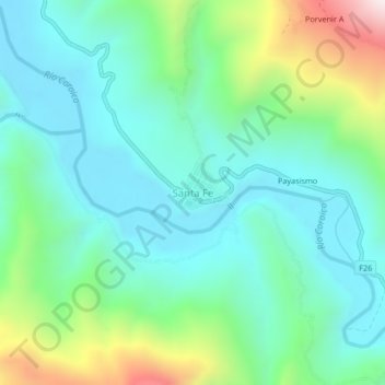
Name: Santa Fe topographic map, elevation, terrain.
Location: Santa Fe, Caranavi, La Paz, Bolivia (-15.82916 -67.64489 -15.78916 -67.60489)
Average elevation: 746 m
Minimum elevation: 529 m
Maximum elevation: 1,388 m
Thank you for supporting this site ❤️
Make a donation
Make a donation
Other topographic maps
Click on a map to view its topography, its elevation and its terrain.