
Chemeketa Park topographic map
Interactive map
Click on the map to display elevation.
About this map
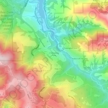
Name: Chemeketa Park topographic map, elevation, terrain.
Average elevation: 413 m
Minimum elevation: 182 m
Maximum elevation: 687 m
Other topographic maps
Click on a map to view its topography, its elevation and its terrain.
Lexington Hills
United States > California > Santa Clara County > Redwood Estates
Lexington Hills, Redwood Estates, Santa Clara County, CAL Fire Northern Region, California, United States
Average elevation: 424 m
Holy City
United States > California > Santa Clara County > Redwood Estates
Holy City, Redwood Estates, Santa Clara County, California, 95033, United States
Average elevation: 429 m
Lexington Hills
United States > California > Santa Clara County > Redwood Estates > Lexington Hills
Lexington Hills, Redwood Estates, Santa Clara County, California, 95044, United States
Average elevation: 406 m