
Thank you for supporting this site ❤️
Make a donation
Make a donation
Ben-Ahin topographic map
Click on the map to display elevation.
Thank you for supporting this site ❤️
Make a donation
Make a donation
About this map
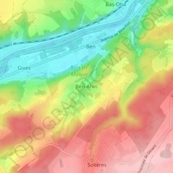
Name: Ben-Ahin topographic map, elevation, terrain.
Location: Ben-Ahin, Huy, Liège, Wallonie, 4500, Belgique (50.48332 5.15735 50.52332 5.19735)
Average elevation: 164 m
Minimum elevation: 65 m
Maximum elevation: 265 m
Thank you for supporting this site ❤️
Make a donation
Make a donation
Other topographic maps
Click on a map to view its topography, its elevation and its terrain.