
Make a donation
Groot-Marico topographic map
Click on the map to display elevation.
Make a donation
Groot-Marico
The topography comprises dry bushveld with a climate that is ideal for cattle, maize, citrus fruit and tobacco. Open pit quarries in the area extract marble, slate and andalusite, with prospects of large-scale nickel mining on the banks of the Groot Marico river as well as the majority of the farms surrounding the hamlet having sparked a successful regional petition against such development. In 2016 a new diamond prospecting application was initiated, bringing a new round of local community objections and petitioning.
Make a donation
About this map
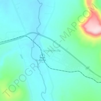
Name: Groot-Marico topographic map, elevation, terrain.
Average elevation: 1,145 m
Minimum elevation: 1,081 m
Maximum elevation: 1,414 m
Make a donation
Other topographic maps
Click on a map to view its topography, its elevation and its terrain.
Marico-Bosveld Dam
South Africa > North West > Ngaka Modiri Molema District Municipality > Ramotshere Moiloa Local Municipality
Average elevation: 1,067 m
Ramotshere Moiloa Ward 17
South Africa > North West > Ngaka Modiri Molema District Municipality > Ramotshere Moiloa Local Municipality
Average elevation: 1,188 m