
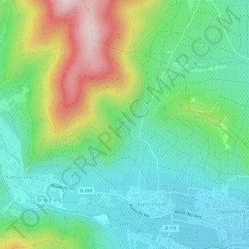
Kientzheim topographic map
Interactive map
Click on the map to display elevation.
About this map
Name: Kientzheim topographic map, elevation, terrain.
Average elevation: 346 m
Minimum elevation: 208 m
Maximum elevation: 657 m
Other topographic maps
Click on a map to view its topography, its elevation and its terrain.
Kaysersberg
France > Grand Est > Haut-Rhin > Kaysersberg-Vignoble
Kaysersberg, Kaysersberg-Vignoble, Colmar-Ribeauvillé, Haut-Rhin, Grand Est, France métropolitaine, 68240, France
Average elevation: 523 m
Château de Kaysersberg
France > Grand Est > Haut-Rhin > Kaysersberg-Vignoble
Château de Kaysersberg, Rue des Forgerons, Kaysersberg, Kaysersberg-Vignoble, Colmar-Ribeauvillé, Haut-Rhin, Grand Est, France métropolitaine, 68240, France
Average elevation: 357 m
Sigolsheim
France > Grand Est > Haut-Rhin > Kaysersberg-Vignoble
Sigolsheim, Kaysersberg-Vignoble, Colmar-Ribeauvillé, Haut-Rhin, Grand Est, France métropolitaine, 68240, France
Average elevation: 228 m