
Make a donation
Hebron topographic map
Click on the map to display elevation.
Make a donation
Hebron
It is one of the highest cities in the area and was, until the 19th century, considered the highest city in the Middle East. With the governorate and metropolitan area, it forms about 19% of the West Bank total area. The city is surrounded by several mountains and hills, including the Hebron Hills (Jabal al–Khalil) and Mount Nabi Yunis. The Mount Nabi Yunis, sitauted north of the city, is the highest point in Palestine, with an altitude of 1,030 metres (3,380 ft). While the Hebron Hills is southern part of the wider Judaean Mountains, which spreads throughout Israel and Palestine and have an altitude of 1,026 m (3,366 ft). The two larger settlements whose population exceeds 7000 sit on the hills overlooking the Hebron's eastern quarters – Kirayt Arba and Givat Harsina. Wadi al–Quff near Hebron is one of the largest natural reserves in Palestine. Located towards northeast of the city, it is surrounded by nearby towns and villages of Tarqumia, Halhoul, Beit Kahel and Beit Ola. The natural reserve covers up an area of 3.73 square kilometres (920 acres). Wadi al–Quff Natural reserve is home to some of the rare species of animals and plants.
Make a donation
About this map
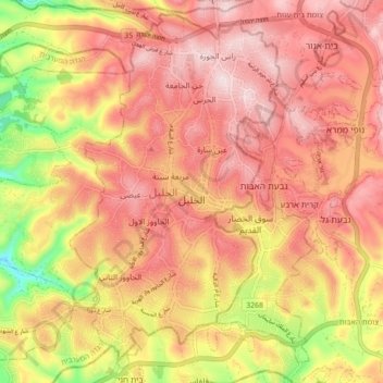
Name: Hebron topographic map, elevation, terrain.
Location: Hebron, Area H1, West Bank, 150, Palestinian Territories (31.49552 35.03433 31.56504 35.12208)
Average elevation: 872 m
Minimum elevation: 600 m
Maximum elevation: 1,019 m
Make a donation