
Olomouc Region topographic map
Interactive map
Click on the map to display elevation.
About this map
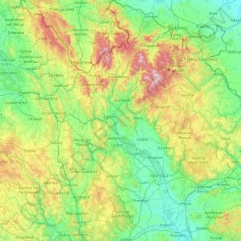
Name: Olomouc Region topographic map, elevation, terrain.
Location: Olomouc Region, Central Moravia, Czechia (49.26879 16.71199 50.44945 17.91811)
Average elevation: 459 m
Minimum elevation: 175 m
Maximum elevation: 1,475 m
Other topographic maps
Click on a map to view its topography, its elevation and its terrain.
Kokory
Czechia > Central Moravia > Kokory
Kokory, okres Přerov, Olomouc Region, Central Moravia, Czechia
Average elevation: 239 m
Přerov
Czechia > Central Moravia > Přerov
Přerov, okres Přerov, Olomouc Region, Central Moravia, Czechia
Average elevation: 236 m