
Make a donation
Oceanside topographic map
Click on the map to display elevation.
Make a donation
Oceanside
Oceanside features a diverse topography characterized by its coastal setting and gentle inland elevations. The city is predominantly flat, with its elevation averaging around 66 feet (20 meters) above sea level, allowing for expansive views of the Pacific Ocean along its roughly 3.5 miles of coastline. Inland, the landscape transitions into low-lying marine terraces and rolling hills, which form a gradual rise towards the San Marcos Mountains, located to the east. These mountains, which reach elevations of up to 1,500 feet, provide a striking contrast to the coastal plains, and are composed of older Mesozoic rocks. The interplay of these geographical features contributes to Oceanside's scenic beauty and makes it a popular destination for outdoor activities, from beachgoers enjoying the surf to hikers exploring the nearby foothills.
Make a donation
About this map
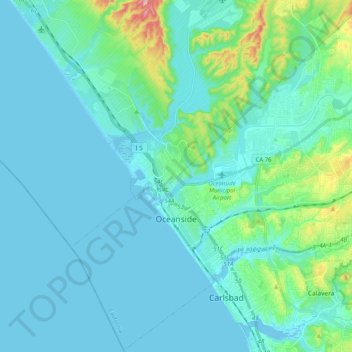
Name: Oceanside topographic map, elevation, terrain.
Location: Oceanside, San Diego County, California, United States (33.13257 -117.43980 33.30003 -117.23789)
Average elevation: 32 m
Minimum elevation: -8 m
Maximum elevation: 240 m
Make a donation
Other topographic maps
Click on a map to view its topography, its elevation and its terrain.
Ramona
United States > California > San Diego County
In January 2006, Ramona Valley was designated the country's 162nd American Viticultural Area (AVA) by the Alcohol and Tobacco Tax and Trade Bureau, which recognized the area for its distinctive microclimate, elevation, and soil attributes.
Average elevation: 469 m
San Diego
United States > California > San Diego County > San Diego
The climate in San Diego, like most of Southern California, often varies significantly over short geographical distances, resulting in microclimates. In San Diego, this is mostly because of the city's topography (the Bay, and the numerous hills, mountains, and canyons). Frequently, particularly during the "May…
Average elevation: 57 m
Make a donation
Rancho Peñasquitos
United States > California > San Diego County > San Diego
The highest point in the community is Black Mountain, which rises to an elevation of 1,500 feet (460 m).
Average elevation: 157 m
Make a donation
Make a donation
Lake Murray Reservoir
United States > California > San Diego County > San Diego > San Carlos
Average elevation: 178 m
Make a donation
Independence Park
United States > California > San Diego County > Chula Vista
Average elevation: 133 m
Make a donation
Make a donation
Make a donation
Make a donation
4S Ranch
United States > California > San Diego County
4S Ranch is underlain by Jurassic Santiago Peak Volcanics, Tertiary Stadium conglomerate, and slope wash alluvium. The land of 4S Ranch before development consisted of a variety of landforms ranging from nearly flat-lying mesas and gently rolling hills to rugged, steeply-sloping hillside terrain. Elevations…
Average elevation: 183 m
Torrey Pines State Natural Reserve
United States > California > San Diego County > San Diego
Average elevation: 37 m
Make a donation
La Jolla Shores Beach
United States > California > San Diego County > San Diego
Average elevation: 39 m
Make a donation
Pala
United States > California > San Diego County
The community is in the Pacific time zone. Pala is at an altitude of 404 feet, located at 33°21′55″N 117°04′36″W / 33.36528°N 117.07667°W / 33.36528; -117.07667 (latitude 33.365N, longitude 117.075W).
Average elevation: 189 m
Case Spring
United States > California > San Diego County > Marine Corps Base Camp Pendleton
Average elevation: 687 m
Make a donation
Make a donation
Make a donation
Make a donation
Make a donation
Make a donation
Make a donation
Make a donation
Flynn Springs County Park
United States > California > San Diego County > El Cajon > Flinn Springs
Average elevation: 330 m
Make a donation
Make a donation
Las Flores
United States > California > San Diego County > Marine Corps Base Camp Pendleton
Average elevation: 21 m
Make a donation
Camp Pendleton
United States > California > San Diego County > Marine Corps Base Camp Pendleton
Average elevation: 24 m
Pine Valley
United States > California > San Diego County
Pine Valley is named for the locally unique strand of Jeffrey pine (Pinus jeffreyi) found along Pine Valley Creek, a seasonal drainage in the foothills of the Laguna Mountains in central San Diego County. According to the United States Geological Survey, Pine Valley is located 3,736 feet (1,139 m) above sea…
Average elevation: 1,291 m
Make a donation
Make a donation