
Kerhoadic topographic map
Interactive map
Click on the map to display elevation.
About this map
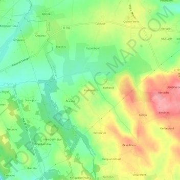
Name: Kerhoadic topographic map, elevation, terrain.
Average elevation: 176 m
Minimum elevation: 130 m
Maximum elevation: 234 m
Other topographic maps
Click on a map to view its topography, its elevation and its terrain.
Chapelle Neuve
France > Bretagne > Morbihan > Guiscriff
Chapelle Neuve, Guiscriff, Pontivy, Morbihan, Bretagne, France métropolitaine, 56560, France
Average elevation: 170 m