
Thank you for supporting this site ❤️
Make a donation
Make a donation
Castel Volturno topographic map
Click on the map to display elevation.
Thank you for supporting this site ❤️
Make a donation
Make a donation
About this map
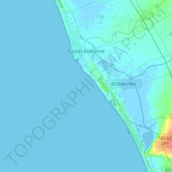
Name: Castel Volturno topographic map, elevation, terrain.
Location: Castel Volturno, Caserta, Campania, 81130, Italy (40.89878 13.90266 41.09092 14.03571)
Average elevation: 1 m
Minimum elevation: -4 m
Maximum elevation: 35 m
Thank you for supporting this site ❤️
Make a donation
Make a donation
Other topographic maps
Click on a map to view its topography, its elevation and its terrain.
Thank you for supporting this site ❤️
Make a donation
Make a donation
Thank you for supporting this site ❤️
Make a donation
Make a donation