
Make a donation
Odesa topographic map
Click on the map to display elevation.
Make a donation
Odesa
The city is situated on terraced hills overlooking a small harbor. The average elevation at which the city is located is around 50 metres (160 feet). The maximum is 65 metres (213 feet) and minimum (on the coast) amounts to 4.2 metres (13.8 feet) above sea level. There are three large estuaries near the city: Kuialnyk, Khadzhibey and Sukhyi.
Make a donation
About this map
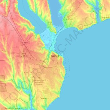
Name: Odesa topographic map, elevation, terrain.
Location: Odesa, Odesa Urban Hromada, Odesa Raion, Odesa Oblast, Ukraine (46.34267 30.61140 46.62912 30.83138)
Average elevation: 26 m
Minimum elevation: -8 m
Maximum elevation: 83 m
Make a donation
Other topographic maps
Click on a map to view its topography, its elevation and its terrain.
Make a donation
Make a donation
Make a donation
Make a donation
Make a donation
Make a donation
Make a donation
Izmail
Under the Köppen climate classification, Izmail falls within either a hot-summer humid continental climate (Dfa) if the 0 °C (32 °F) isotherm is used or a humid subtropical climate (Cfa) if the −3 °C (27 °F) isotherm is used. Izmail experiences four distinct seasons and generous precipitation…
Average elevation: 19 m
Make a donation
Make a donation