
Thank you for supporting this site ❤️
Make a donation
Make a donation
Poxstall topographic map
Click on the map to display elevation.
Thank you for supporting this site ❤️
Make a donation
Make a donation
Poxstall
Das in der Wiesentalb gelegene Dorf liegt etwa dreieinhalb Kilometer westsüdwestlich des Ortszentrums von Ebermannstadt auf einer Höhe von 392 m ü. NHN.
Thank you for supporting this site ❤️
Make a donation
Make a donation
About this map
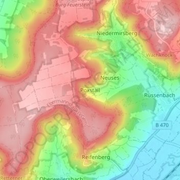
Name: Poxstall topographic map, elevation, terrain.
Average elevation: 417 m
Minimum elevation: 282 m
Maximum elevation: 530 m
Thank you for supporting this site ❤️
Make a donation
Make a donation
Other topographic maps
Click on a map to view its topography, its elevation and its terrain.
Breitenbach
Deutschland > Bayern > Landkreis Forchheim > Ebermannstadt > Breitenbach
Average elevation: 368 m