
The Springs topographic map
Interactive map
Click on the map to display elevation.
About this map
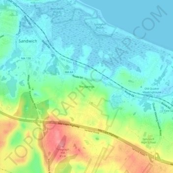
Name: The Springs topographic map, elevation, terrain.
Average elevation: 26 m
Minimum elevation: -2 m
Maximum elevation: 87 m
Other topographic maps
Click on a map to view its topography, its elevation and its terrain.
Sandwich Fish Hatchery
United States > Massachusetts > Barnstable County > Sandwich
Sandwich Fish Hatchery, Armstrong Farm Road, Sandwich, Barnstable County, Massachusetts, 02763, United States
Average elevation: 23 m
Peters Pond
United States > Massachusetts > Barnstable County > Sandwich > Forestdale
Peters Pond, Forestdale, Sandwich, Barnstable County, Massachusetts, United States
Average elevation: 40 m