
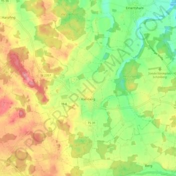
Kienberg topographic map
Interactive map
Click on the map to display elevation.
About this map
Name: Kienberg topographic map, elevation, terrain.
Average elevation: 549 m
Minimum elevation: 497 m
Maximum elevation: 604 m
Other topographic maps
Click on a map to view its topography, its elevation and its terrain.
Siegsdorf
Allemagne > Bavière > Landkreis Traunstein
Siegsdorf, Landkreis Traunstein, Bavière, 83313, Allemagne
Average elevation: 734 m
Chiemsee
Allemagne > Bavière > Landkreis Traunstein
Chiemsee, Landkreis Traunstein, Bavière, Allemagne
Average elevation: 525 m
Reit im Winkl
Allemagne > Bavière > Landkreis Traunstein
Reit im Winkl, Landkreis Traunstein, Bavière, 83242, Allemagne
Average elevation: 949 m
Hinterbichl
Allemagne > Bavière > Landkreis Traunstein > Inzell
Hinterbichl, Inzell, Landkreis Traunstein, Bavière, 83334, Allemagne
Average elevation: 798 m
Brem
Allemagne > Bavière > Landkreis Traunstein > Oberwössen > Brem
Brem, Oberwössen, Unterwössen, Landkreis Traunstein, Bavière, 83246, Allemagne
Average elevation: 811 m
Ruhpolding
Allemagne > Bavière > Landkreis Traunstein
Ruhpolding, Landkreis Traunstein, Bavière, 83324, Allemagne
Average elevation: 988 m
lac de Chiem
Allemagne > Bavière > Landkreis Traunstein > Chiemsee
lac de Chiem, Chiemsee, Breitbrunn am Chiemsee (VGem), Landkreis Traunstein, Bavière, Allemagne
Average elevation: 527 m