
Thank you for supporting this site ❤️
Make a donation
Make a donation
Heesdonk topographic map
Click on the map to display elevation.
Thank you for supporting this site ❤️
Make a donation
Make a donation
About this map
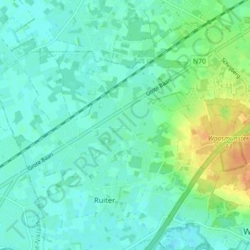
Name: Heesdonk topographic map, elevation, terrain.
Average elevation: 9 m
Minimum elevation: -1 m
Maximum elevation: 33 m
Thank you for supporting this site ❤️
Make a donation
Make a donation
Other topographic maps
Click on a map to view its topography, its elevation and its terrain.
Cuesta van het Waasland te Waasmunster
België > Oost-Vlaanderen > Dendermonde > Waasmunster > Ruiter
Average elevation: 18 m