
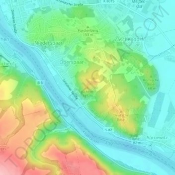
Juchhöh topographic map
Interactive map
Click on the map to display elevation.
About this map
Name: Juchhöh topographic map, elevation, terrain.
Location: Juchhöh, Meißen, Sachsen, 01662, Deutschland (51.14529 13.50313 51.14539 13.50323)
Average elevation: 138 m
Minimum elevation: 94 m
Maximum elevation: 236 m
Other topographic maps
Click on a map to view its topography, its elevation and its terrain.
Albrechtsburg
Deutschland > Sachsen > Meißen > Meißen
Albrechtsburg, 1, Domplatz, Altstadt, Meißen, Sachsen, 01662, Deutschland
Average elevation: 137 m
Karlshöhe
Deutschland > Sachsen > Meißen > Meißen
Karlshöhe, Meißen, Sachsen, 01662, Deutschland
Average elevation: 133 m