
Seidewitz topographic map
Interactive map
Click on the map to display elevation.
About this map
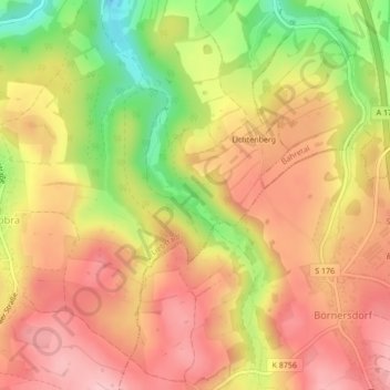
Name: Seidewitz topographic map, elevation, terrain.
Average elevation: 467 m
Minimum elevation: 368 m
Maximum elevation: 531 m
Other topographic maps
Click on a map to view its topography, its elevation and its terrain.
Schloss Kuckuckstein
Deutschland > Sachsen > Liebstadt
Schloss Kuckuckstein, 1, Am Schlossberg, Rotes Vorwerk, Liebstadt, Bad Gottleuba-Berggießhübel, Sächsische Schweiz-Osterzgebirge, Sachsen, 01825, Deutschland
Average elevation: 403 m