
Plant City topographic map
Interactive map
Click on the map to display elevation.
About this map
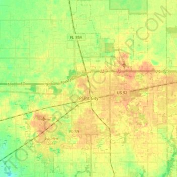
Name: Plant City topographic map, elevation, terrain.
Location: Plant City, Hillsborough County, Florida, United States (27.95593 -82.18708 28.09113 -82.05567)
Average elevation: 38 m
Minimum elevation: 18 m
Maximum elevation: 53 m
Other topographic maps
Click on a map to view its topography, its elevation and its terrain.
Tampa
United States > Florida > Hillsborough County
Tampa, Hillsborough County, Florida, United States
Average elevation: 11 m
Tampa Bay
United States > Florida > Hillsborough County
Tampa Bay, Hillsborough County, Florida, United States
Average elevation: 0 m
Penner
United States > Florida > Hillsborough County
Penner, Hillsborough County, Florida, 33615, United States
Average elevation: 6 m
Apollo Beach
United States > Florida > Hillsborough County
Apollo Beach, Hillsborough County, Florida, 33572, United States
Average elevation: 6 m
Balm
United States > Florida > Hillsborough County
Balm, Hillsborough County, Florida, 33503, United States
Average elevation: 38 m
Alafia River
United States > Florida > Hillsborough County > Brandon
Alafia River, Brandon, Hillsborough County, Florida, United States
Average elevation: 20 m
Citrus Park
United States > Florida > Hillsborough County
Citrus Park, Hillsborough County, Florida, 33625, United States
Average elevation: 13 m
Dover
United States > Florida > Hillsborough County > Brandon > Aarons Place
Dover, Aarons Place, Brandon, Hillsborough County, Florida, 33527, United States
Average elevation: 33 m
Alfredo Trujillo
United States > Florida > Hillsborough County
Alfredo Trujillo, Hillsborough County, Florida, 33615, United States
Average elevation: 6 m
Amelia
United States > Florida > Hillsborough County > Tampa
Amelia, Tampa, Hillsborough County, Florida, 33608, United States
Average elevation: 9 m
Bay Port Colony
United States > Florida > Hillsborough County
Bay Port Colony, Hillsborough County, Florida, 33635, United States
Average elevation: 4 m
North Ruskin
United States > Florida > Hillsborough County
North Ruskin, Hillsborough County, Florida, 33572, United States
Average elevation: 7 m
Arbor Greene
United States > Florida > Hillsborough County > Tampa
Arbor Greene, Tampa, Hillsborough County, Florida, 33647, United States
Average elevation: 18 m
Alta Vista Tracts
United States > Florida > Hillsborough County > Tampa
Alta Vista Tracts, Tampa, Hillsborough County, Florida, 33611, United States
Average elevation: 7 m
Arlington Heights North
United States > Florida > Hillsborough County > Tampa
Arlington Heights North, Tampa, Hillsborough County, Florida, 33603, United States
Average elevation: 15 m
Armenia Acres
United States > Florida > Hillsborough County > Tampa
Armenia Acres, Tampa, Hillsborough County, Florida, 33612, United States
Average elevation: 16 m
The Reserve of Old Tampa Bay
United States > Florida > Hillsborough County
The Reserve of Old Tampa Bay, Hillsborough County, Florida, 33615, United States
Average elevation: 3 m
Al Dana Park
United States > Florida > Hillsborough County > Tampa
Al Dana Park, Tampa, Hillsborough County, Florida, 33614, United States
Average elevation: 14 m
Arrawana Park
United States > Florida > Hillsborough County > Tampa
Arrawana Park, Tampa, Hillsborough County, Florida, 33609, United States
Average elevation: 11 m
East Tampa
United States > Florida > Hillsborough County
East Tampa, Hillsborough County, Florida, 33534, United States
Average elevation: 8 m
Aberdeen on Glen
United States > Florida > Hillsborough County > Tampa
Aberdeen on Glen, Tampa, Hillsborough County, Florida, 33609, United States
Average elevation: 11 m
Turnberry at the Eagles
United States > Florida > Hillsborough County
Turnberry at the Eagles, Hillsborough County, Florida, United States
Average elevation: 9 m
Twin Branch Acres
United States > Florida > Hillsborough County
Twin Branch Acres, Hillsborough County, Florida, 33626, United States
Average elevation: 6 m
Wimauma
United States > Florida > Hillsborough County
Wimauma, Hillsborough County, Florida, United States
Average elevation: 23 m
Andrea
United States > Florida > Hillsborough County > Tampa
Andrea, Tampa, Hillsborough County, Florida, 33609, United States
Average elevation: 10 m
Thonotosassa
United States > Florida > Hillsborough County
Thonotosassa, Hillsborough County, Florida, 33592, United States
Average elevation: 20 m
Seffner
United States > Florida > Hillsborough County > Seffner
Seffner, Hillsborough County, Florida, 33584, United States
Average elevation: 23 m
Town "n" Country
United States > Florida > Hillsborough County > Tampa
Town "n" Country, Tampa, Hillsborough County, Florida, United States
Average elevation: 7 m
Pebble Creek
United States > Florida > Hillsborough County > Tampa
Pebble Creek, Tampa, Hillsborough County, Florida, United States
Average elevation: 20 m
Sun City Center
United States > Florida > Hillsborough County
Sun City Center, Hillsborough County, Florida, 33573, United States
Average elevation: 17 m
Brandon
United States > Florida > Hillsborough County
Brandon, Hillsborough County, Florida, United States
Average elevation: 19 m
Riverview
United States > Florida > Hillsborough County
Riverview, Hillsborough County, Florida, 33568, United States
Average elevation: 13 m
Ruskin
United States > Florida > Hillsborough County
Ruskin, Hillsborough County, Florida, 33570, United States
Average elevation: 7 m
Sun City
United States > Florida > Hillsborough County > Sun City
Sun City, Hillsborough County, Florida, 33586, United States
Average elevation: 5 m
Port Tampa
United States > Florida > Hillsborough County > Tampa
Port Tampa, Tampa, Hillsborough County, Florida, 33616, United States
Average elevation: 4 m
Thonotosassa
United States > Florida > Hillsborough County
Thonotosassa, Hillsborough County, Florida, 33574, United States
Average elevation: 19 m
Valrico
United States > Florida > Hillsborough County > Angel Run
Valrico, Angel Run, Hillsborough County, Florida, United States
Average elevation: 25 m
Temple Terrace
United States > Florida > Hillsborough County > Temple Terrace
Temple Terrace, Hillsborough County, Florida, United States
Average elevation: 17 m
Lutz
United States > Florida > Hillsborough County
Lutz, Hillsborough County, Florida, 33548, United States
Average elevation: 21 m
Gibsonton
United States > Florida > Hillsborough County > Riverview
Gibsonton, Riverview, Hillsborough County, Florida, 33534, United States
Average elevation: 7 m
Lake Magdalene
United States > Florida > Hillsborough County
Lake Magdalene, Hillsborough County, Florida, 33613, United States
Average elevation: 18 m
Lutz
United States > Florida > Hillsborough County > Tampa
Lutz, Tampa, Hillsborough County, Florida, United States
Average elevation: 20 m