
Tacheta Zougagha topographic map
Interactive map
Click on the map to display elevation.
About this map
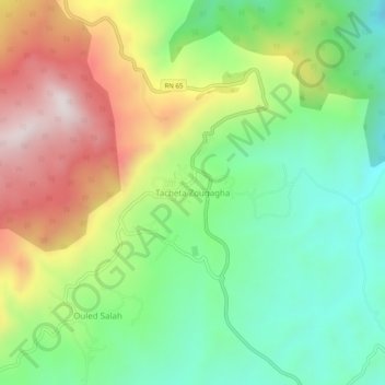
Name: Tacheta Zougagha topographic map, elevation, terrain.
Average elevation: 582 m
Minimum elevation: 296 m
Maximum elevation: 1,010 m
Other topographic maps
Click on a map to view its topography, its elevation and its terrain.
Ouled Salah
Algérie > Aïn Defla > Daïra El Abadia > Tacheta Zoughagha
Ouled Salah, Tacheta Zoughagha, Daïra El Abadia, Aïn Defla, Algérie
Average elevation: 583 m