
Mostaganem topographic map
Interactive map
Click on the map to display elevation.
About this map
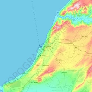
Name: Mostaganem topographic map, elevation, terrain.
Location: Mostaganem, daïra Mostaganem, Mostaganem, 27000, Algérie (35.76881 -0.07002 36.08881 0.24998)
Average elevation: 86 m
Minimum elevation: -1 m
Maximum elevation: 413 m
Mostaganem est située à 104 mètres d'altitude sur le rebord d’un plateau côtier. La ville contemple à l’ouest la large baie d’Arzew que termine le djebel Orousse.
Other topographic maps
Click on a map to view its topography, its elevation and its terrain.
Douar Oued Cheliff
Algérie > Mostaganem > daïra Mostaganem > Mostaganem
Douar Oued Cheliff, Mostaganem, daïra Mostaganem, Mostaganem, Algérie
Average elevation: 48 m