
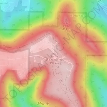
Monte Sano Mountain topographic map
Interactive map
Click on the map to display elevation.
About this map
Name: Monte Sano Mountain topographic map, elevation, terrain.
Average elevation: 396 m
Minimum elevation: 221 m
Maximum elevation: 504 m
The top is relatively flat and lies just under 500 meters above sea level. This elevation is about 300 meters higher than the floor of the Tennessee Valley, which surrounds it. A residential neighborhood occupies the western portion of the top. The eastern portion and slopes of the mountain are occupied by Monte Sano State Park. Monte Sano is connected to Round Top (Burritt) Mountain by a col to the south.
Other topographic maps
Click on a map to view its topography, its elevation and its terrain.
Huntsville
United States > Alabama > Madison County
Huntsville, Madison County, Alabama, United States
Average elevation: 230 m
Hazel Green
United States > Alabama > Madison County > Hazel Green
Hazel Green, Madison County, Alabama, 35750, United States
Average elevation: 239 m
Gurley
United States > Alabama > Madison County
Gurley, Madison County, Alabama, United States
Average elevation: 234 m
Mercury
United States > Alabama > Madison County > Huntsville
Mercury, Huntsville, Madison County, Alabama, 35811, United States
Average elevation: 242 m
Oak Park
United States > Alabama > Madison County > Huntsville
Oak Park, Huntsville, Madison County, Alabama, 35801, United States
Average elevation: 281 m
Jones Valley Estates
United States > Alabama > Madison County > Huntsville
Jones Valley Estates, Huntsville, Madison County, Alabama, 35802, United States
Average elevation: 208 m
Hazel Green
United States > Alabama > Madison County
Hazel Green, Madison County, Alabama, 35750, United States
Average elevation: 240 m
University Park
United States > Alabama > Madison County > Huntsville
University Park, Huntsville, Madison County, Alabama, 35816, United States
Average elevation: 207 m
Piedmont
United States > Alabama > Madison County > Huntsville
Piedmont, Huntsville, Madison County, Alabama, 32802, United States
Average elevation: 204 m
Owens Cross Roads
United States > Alabama > Madison County
Owens Cross Roads, Madison County, Alabama, United States
Average elevation: 195 m
Monte Sano State Park
United States > Alabama > Madison County > Huntsville
Monte Sano State Park, Huntsville, Madison County, Alabama, United States
Average elevation: 351 m
Parkway Estates
United States > Alabama > Madison County > Huntsville
Parkway Estates, Huntsville, Madison County, Alabama, 35802, United States
Average elevation: 187 m
Walker Woods
United States > Alabama > Madison County > Huntsville
Walker Woods, Huntsville, Madison County, Alabama, 32802, United States
Average elevation: 288 m
Greenwycke Village
United States > Alabama > Madison County > Huntsville
Greenwycke Village, Huntsville, Madison County, Alabama, 32802, United States
Average elevation: 254 m
Hazel Green
United States > Alabama > Madison County
Hazel Green, Madison County, Alabama, 35750, United States
Average elevation: 239 m
Camelot
United States > Alabama > Madison County > Huntsville
Camelot, Huntsville, Madison County, Alabama, 35803, United States
Average elevation: 269 m
New Market
United States > Alabama > Madison County
New Market, Madison County, Alabama, United States
Average elevation: 278 m
Huntsville
United States > Alabama > Madison County > Huntsville
Huntsville, Madison County, Alabama, 35804, United States
Average elevation: 225 m
New Hope
United States > Alabama > Madison County
New Hope, Madison County, Alabama, 35760, United States
Average elevation: 182 m
Cherrytree
United States > Alabama > Madison County > Huntsville
Cherrytree, Huntsville, Madison County, Alabama, 35763, United States
Average elevation: 184 m
Gurley
United States > Alabama > Madison County
Gurley, Madison County, Alabama, United States
Average elevation: 234 m
Toney
United States > Alabama > Madison County > Toney
Toney, Madison County, Alabama, 35773, United States
Average elevation: 255 m
Madison
United States > Alabama > Madison County
Madison, Madison County, Alabama, United States
Average elevation: 210 m
Harvest
United States > Alabama > Madison County
Harvest, Madison County, Alabama, United States
Average elevation: 254 m