
Make a donation
Hanbury topographic map
Click on the map to display elevation.
Make a donation
Hanbury
This locality adjoins the River Dove and includes a steep knoll between much of it and the river, Row Hill; five listed buildings are here all at Grade II. Hanbury's village centre is 0.9 miles (1.4 km) to the south. This hamlet is at an elevation of 61m AOD whereas the village centre of Hanbury is at the start of a steep westward valley at the source of the Salt Brook at 134m AOD.
Make a donation
About this map
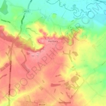
Name: Hanbury topographic map, elevation, terrain.
Average elevation: 107 m
Minimum elevation: 52 m
Maximum elevation: 155 m
Make a donation
Other topographic maps
Click on a map to view its topography, its elevation and its terrain.
Tutbury Castle
United Kingdom > England > Staffordshire > East Staffordshire > Tutbury
Average elevation: 66 m
Burton upon Trent
United Kingdom > England > Staffordshire > East Staffordshire
Burton is about 109 miles (175 km) north west of London, about 30 miles north east of Birmingham, the UK's second largest city and about 23 miles east of the county town Stafford. It is at the easternmost border of the county of Staffordshire with Derbyshire, its suburbs and the course of the River Trent…
Average elevation: 69 m
Stubwood
United Kingdom > England > Staffordshire > East Staffordshire > Denstone
Average elevation: 113 m
Birch Cross
United Kingdom > England > Staffordshire > East Staffordshire > Marchington
Average elevation: 92 m
Make a donation
Gratwich
United Kingdom > England > Staffordshire > East Staffordshire > Kingstone
Average elevation: 143 m
Make a donation
Marchington Woodlands
United Kingdom > England > Staffordshire > East Staffordshire
Average elevation: 120 m
Blithfield Reservoir
United Kingdom > England > Staffordshire > East Staffordshire > Admaston
Average elevation: 108 m
Make a donation
Harlow Wood
United Kingdom > England > Staffordshire > East Staffordshire > Upper Mayfield
Average elevation: 177 m
Burton upon Trent
United Kingdom > England > Staffordshire > East Staffordshire
Burton is about 109 miles (175 km) north west of London, about 30 miles north east of Birmingham, the UK's second largest city and about 23 miles east of the county town Stafford. It is at the easternmost border of the county of Staffordshire with Derbyshire, its suburbs and the course of the River Trent…
Average elevation: 69 m
Make a donation