
Thank you for supporting this site ❤️
Make a donation
Make a donation
Marshfield Hills topographic map
Click on the map to display elevation.
Thank you for supporting this site ❤️
Make a donation
Make a donation
About this map
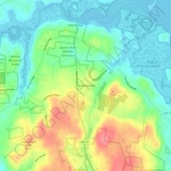
Name: Marshfield Hills topographic map, elevation, terrain.
Average elevation: 29 m
Minimum elevation: -2 m
Maximum elevation: 78 m
Thank you for supporting this site ❤️
Make a donation
Make a donation
Other topographic maps
Click on a map to view its topography, its elevation and its terrain.
Green Harbor River
United States > Massachusetts > Plymouth County > Marshfield > Green Harbor
Average elevation: 2 m