
Bellevue topographic map
Interactive map
Click on the map to display elevation.
About this map
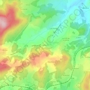
Name: Bellevue topographic map, elevation, terrain.
Average elevation: 415 m
Minimum elevation: 319 m
Maximum elevation: 548 m
Other topographic maps
Click on a map to view its topography, its elevation and its terrain.
Les Gravilles
France > Nouvelle-Aquitaine > Haute-Vienne > Rilhac-Lastours > Lastours
Les Gravilles, Lastours, Rilhac-Lastours, Limoges, Haute-Vienne, Nouvelle-Aquitaine, France métropolitaine, 87800, France
Average elevation: 408 m
Motte Féodale
France > Nouvelle-Aquitaine > Haute-Vienne > Rilhac-Lastours > Lastours > Bellevue
Motte Féodale, C 24, Bellevue, Lastours, Rilhac-Lastours, Limoges, Haute-Vienne, Nouvelle-Aquitaine, France métropolitaine, 87800, France
Average elevation: 411 m