
Lancaster topographic map
Interactive map
Click on the map to display elevation.
About this map
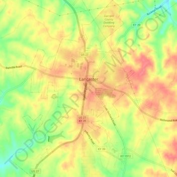
Name: Lancaster topographic map, elevation, terrain.
Location: Lancaster, Garrard County, Kentucky, United States (37.59573 -84.60228 37.63875 -84.56388)
Average elevation: 296 m
Minimum elevation: 255 m
Maximum elevation: 324 m
Other topographic maps
Click on a map to view its topography, its elevation and its terrain.
Paint Lick
United States > Kentucky > Garrard County
Paint Lick, Garrard County, Kentucky, 40461, United States
Average elevation: 272 m
Bryantsville
United States > Kentucky > Garrard County
Bryantsville, Garrard County, Kentucky, 40410, United States
Average elevation: 281 m