Geolocate

Thurso topographic map

Interactive map

Click on the map to display elevation.

About this map

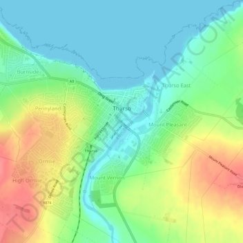
Name: Thurso topographic map, elevation, terrain.

Location: Thurso, Highland, Scotland, United Kingdom (58.58098 -3.55606 58.60531 -3.50003)

Average elevation: 25 m

Minimum elevation: 0 m

Maximum elevation: 68 m

Other topographic maps

Click on a map to view its topography, its elevation and its terrain.

Scottish Highlands

United Kingdom > Scotland > Highland

The Scottish Highlands are renowned for their rugged, mountainous terrain that dominates much of the region. Stretching across the northern and central parts of Scotland, the landscape is shaped by ancient geological forces, including the Caledonian Orogeny, which caused significant tectonic collisions…

Average elevation: 907 m

Portree

United Kingdom > Scotland > Highland

Average elevation: 121 m

Laide

United Kingdom > Scotland > Highland

Average elevation: 47 m

Fortrose

United Kingdom > Scotland > Highland

Average elevation: 50 m

Redpoint

United Kingdom > Scotland > Highland

Average elevation: 37 m

Sciberscross

United Kingdom > Scotland > Highland

Average elevation: 168 m

Kilmory

United Kingdom > Scotland > Highland

Average elevation: 61 m

Fodderty

United Kingdom > Scotland > Highland

Average elevation: 129 m

Lewiston

United Kingdom > Scotland > Highland

Average elevation: 127 m

Kingussie

United Kingdom > Scotland > Highland

Average elevation: 338 m

Tornagrain

United Kingdom > Scotland > Highland > Inverness

Average elevation: 46 m

Newtonmore

United Kingdom > Scotland > Highland

Newtonmore is located within the Cairngorms National Park, approximately 3 miles (5 km) southwest of Kingussie and 15 miles (24 km) southwest of Aviemore. It is on the northeastern bank of the River Spey, between the River Calder and the Allt Lairaidh, at an altitude of approximately 250 metres (820 ft).

Average elevation: 283 m

Ullapool

United Kingdom > Scotland > Highland

Average elevation: 150 m

Cairn Gorm

United Kingdom > Scotland > Highland

Cairn Gorm (Scottish Gaelic: An Càrn Gorm) is a mountain in the Scottish Highlands. It is part of the Cairngorms range and wider Grampian Mountains. With a summit elevation of 1,245 m (4,085 ft) above sea level, Cairn Gorm is classed as a Munro and is the sixth-highest mountain in the British Isles. The high,…

Average elevation: 989 m

Struy

United Kingdom > Scotland > Highland

Average elevation: 164 m

Carbost

United Kingdom > Scotland > Highland

Average elevation: 110 m

Tomnacross

United Kingdom > Scotland > Highland > Kiltarlity

Average elevation: 87 m

Nairn

United Kingdom > Scotland > Highland

Average elevation: 18 m

Craigton

United Kingdom > Scotland > Highland > North Kessock

Average elevation: 30 m

Lairg Muir

United Kingdom > Scotland > Highland > Lairg

Average elevation: 138 m

Glen Hill

United Kingdom > Scotland > Highland

Average elevation: 205 m

Dunvegan

United Kingdom > Scotland > Highland

Average elevation: 41 m

Newport

United Kingdom > Scotland > Highland

Average elevation: 77 m

Gairloch

United Kingdom > Scotland > Highland > Gairloch

Average elevation: 83 m

Torlundy

United Kingdom > Scotland > Highland > Torlundy

Average elevation: 90 m

Alvie

United Kingdom > Scotland > Highland > Alvie

Average elevation: 285 m

Salen

United Kingdom > Scotland > Highland > Salen

Average elevation: 83 m

Pinnacle Ridge

United Kingdom > Scotland > Highland

Average elevation: 472 m

Kentallen

United Kingdom > Scotland > Highland

Average elevation: 204 m

Attadale

United Kingdom > Scotland > Highland

Average elevation: 122 m

Applecross

United Kingdom > Scotland > Highland

Average elevation: 149 m

Kyleakin

United Kingdom > Scotland > Highland > Kyleakin

Average elevation: 48 m

Fort Augustus

United Kingdom > Scotland > Highland

As with most of the British Isles and Scotland, Fort Augustus has an oceanic climate (Köppen: Cfb) with cool summers and mild winters. Like a lot of the surrounding area, sunshine levels are low at around 1,000 hours per annum and temperatures are unpredictable – Fort Augustus holds the UK's joint lowest…

Average elevation: 115 m