
Thank you for supporting this site ❤️
Make a donation
Make a donation
Hambeek topographic map
Click on the map to display elevation.
Thank you for supporting this site ❤️
Make a donation
Make a donation
About this map
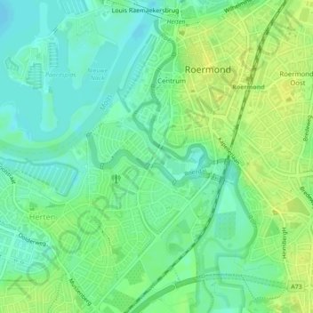
Name: Hambeek topographic map, elevation, terrain.
Location: Hambeek, Roermond, Limburg, Nederland, 6041SK, Nederland (51.18338 5.97156 51.18829 5.99210)
Average elevation: 24 m
Minimum elevation: 15 m
Maximum elevation: 33 m
Thank you for supporting this site ❤️
Make a donation
Make a donation
Other topographic maps
Click on a map to view its topography, its elevation and its terrain.
Roermond
Nederland > Limburg > Roermond
Roermond werd in 1130 Ruregemunde genoemd. Het eerste woorddeel verwijst naar de rivier Roer, die genoemd zou zijn naar een Keltisch-Germaanse watergodin "Rura". Het tweede woorddeel lijkt te verwijzen naar de "monding" van de Roer, maar dit is minder waarschijnlijk aangezien de Roer en de Maas tot ±1340 aan…
Average elevation: 39 m
Thank you for supporting this site ❤️
Make a donation
Make a donation