
Amblie topographic map
Interactive map
Click on the map to display elevation.
About this map
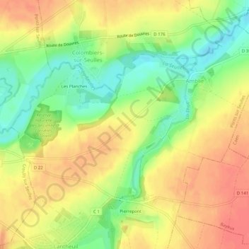
Name: Amblie topographic map, elevation, terrain.
Average elevation: 33 m
Minimum elevation: 0 m
Maximum elevation: 58 m
Other topographic maps
Click on a map to view its topography, its elevation and its terrain.
Lantheuil
France > Normandie > Calvados > Ponts sur Seulles
Lantheuil, Ponts sur Seulles, Bayeux, Calvados, Normandie, France métropolitaine, 14480, France
Average elevation: 42 m
Tierceville
France > Normandie > Calvados > Ponts sur Seulles > Tierceville
Tierceville, Ponts sur Seulles, Bayeux, Calvados, Normandie, France métropolitaine, 14480, France
Average elevation: 37 m