
Al Rayyan topographic map
Interactive map
Click on the map to display elevation.
About this map
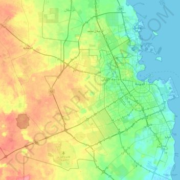
Name: Al Rayyan topographic map, elevation, terrain.
Location: Al Rayyan, Qatar (24.47075 50.79549 25.39018 51.54099)
Average elevation: 37 m
Minimum elevation: -2 m
Maximum elevation: 143 m
Similar to many other names given to Qatari settlements and municipalities, Al Rayyan Municipality was named after a geographic feature present in its namesake, the city of Al Rayyan. The city derives its name from the Arabic term "ray", which translates to "irrigation". This name was bestowed upon it due to its low elevation, allowing it to act as a flood plain and provide a sustained supply of water to the numerous plants that grew within its boundaries.
Other topographic maps
Click on a map to view its topography, its elevation and its terrain.
Oxygen Park
Oxygen Park, Education City, Al Rayyan, Qatar
Average elevation: 13 m
al Koot Fort
al Koot Fort, Jasim Bin Mohammed Street, Al Jasra, Doha, Qatar
Average elevation: 9 m
Fereej Al Manseer
Fereej Al Manseer, Al Rayyan, Ar Rayyan, 93035, Qatar
Average elevation: 26 m
Qurayn Abu al Bawl
Qurayn Abu al Bawl, Jariyan Al Batnah, Qatar
Average elevation: 76 m