
Tannersville topographic map
Interactive map
Click on the map to display elevation.
About this map
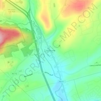
Name: Tannersville topographic map, elevation, terrain.
Average elevation: 316 m
Minimum elevation: 244 m
Maximum elevation: 443 m
Other topographic maps
Click on a map to view its topography, its elevation and its terrain.
Big Pocono State Park
United States > Pennsylvania > Monroe County > Pocono Township
Big Pocono State Park, Mountain Shadows Lane, Pocono Township, Monroe County, Pennsylvania, 18372, United States
Average elevation: 423 m
Bartonsville
United States > Pennsylvania > Monroe County > Pocono Township
Bartonsville, Pocono Township, Monroe County, Pennsylvania, 18321, United States
Average elevation: 265 m
Swiftwater
United States > Pennsylvania > Monroe County > Pocono Township
Swiftwater, Pocono Township, Monroe County, Pennsylvania, 18370, United States
Average elevation: 387 m
Scotrun
United States > Pennsylvania > Monroe County > Pocono Township > Scotrun
Scotrun, Pocono Township, Monroe County, Pennsylvania, 18355, United States
Average elevation: 370 m