
Albuquerque topographic map
Interactive map
Click on the map to display elevation.
About this map
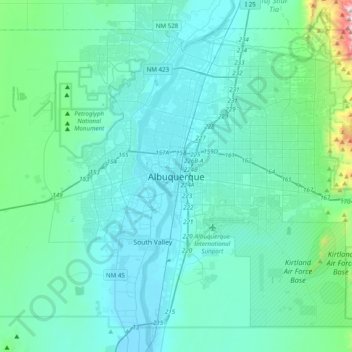
Name: Albuquerque topographic map, elevation, terrain.
Average elevation: 1,671 m
Minimum elevation: 1,491 m
Maximum elevation: 3,162 m
Albuquerque befindet sich in einer Ebene, die im Osten durch die Sandia Mountains und im Westen durch den, von Nord nach Süd fließenden, Rio Grande begrenzt wird. Das Stadtgebiet umfasst ein Gebiet von 469,6 km2, das sich über Höhenlagen zwischen 1.490 m und 1.631 m erstreckt.