
Fremont County topographic map
Interactive map
Click on the map to display elevation.
About this map
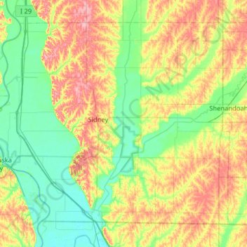
Name: Fremont County topographic map, elevation, terrain.
Location: Fremont County, Iowa, Vereinigte Staaten von Amerika (40.58050 -95.88891 40.90234 -95.37067)
Average elevation: 314 m
Minimum elevation: 274 m
Maximum elevation: 388 m
Other topographic maps
Click on a map to view its topography, its elevation and its terrain.
Linn County
Vereinigte Staaten von Amerika > Iowa
Linn County, Iowa, Vereinigte Staaten von Amerika
Average elevation: 261 m
Schaller
Vereinigte Staaten von Amerika > Iowa > Sac County
Schaller, Sac County, Iowa, Vereinigte Staaten von Amerika
Average elevation: 433 m
Ida County
Vereinigte Staaten von Amerika > Iowa
Ida County, Iowa, Vereinigte Staaten von Amerika
Average elevation: 415 m
Story County
Vereinigte Staaten von Amerika > Iowa
Story County, Iowa, Vereinigte Staaten von Amerika
Average elevation: 308 m