
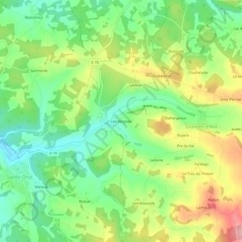
Les Vergnes topographic map
Interactive map
Click on the map to display elevation.
About this map
Name: Les Vergnes topographic map, elevation, terrain.
Average elevation: 243 m
Minimum elevation: 179 m
Maximum elevation: 337 m
Other topographic maps
Click on a map to view its topography, its elevation and its terrain.
Lachaud
France > Nouvelle-Aquitaine > Dordogne > Granges-d'Ans
Lachaud, Granges-d'Ans, Sarlat-la-Canéda, Dordogne, Nouvelle-Aquitaine, France métropolitaine, 24390, France
Average elevation: 271 m
La Fontaine
France > Nouvelle-Aquitaine > Dordogne > Granges-d'Ans > La Fontaine
La Fontaine, Granges-d'Ans, Sarlat-la-Canéda, Dordogne, Nouvelle-Aquitaine, France métropolitaine, 24390, France
Average elevation: 261 m
Baillargeaux
France > Nouvelle-Aquitaine > Dordogne > Granges-d'Ans > Baillargeaux
Baillargeaux, Granges-d'Ans, Sarlat-la-Canéda, Dordogne, Nouvelle-Aquitaine, France métropolitaine, 24390, France
Average elevation: 255 m