
Thank you for supporting this site ❤️
Make a donation
Make a donation
Grandhan topographic map
Click on the map to display elevation.
Thank you for supporting this site ❤️
Make a donation
Make a donation
About this map
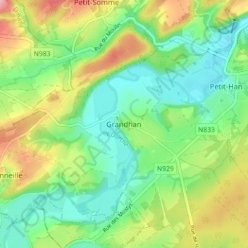
Name: Grandhan topographic map, elevation, terrain.
Location: Grandhan, Durbuy, Marche-en-Famenne, Luxemburg, Wallonië, België (50.30998 5.38867 50.34998 5.42867)
Average elevation: 186 m
Minimum elevation: 143 m
Maximum elevation: 259 m
Thank you for supporting this site ❤️
Make a donation
Make a donation
Other topographic maps
Click on a map to view its topography, its elevation and its terrain.
Thank you for supporting this site ❤️
Make a donation
Make a donation
Thank you for supporting this site ❤️
Make a donation
Make a donation
Thank you for supporting this site ❤️
Make a donation
Make a donation