
Knox County topographic map
Interactive map
Click on the map to display elevation.
About this map
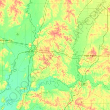
Name: Knox County topographic map, elevation, terrain.
Location: Knox County, Indiana, Estados Unidos (38.41401 -87.74413 38.91036 -87.09423)
Average elevation: 142 m
Minimum elevation: 115 m
Maximum elevation: 204 m
Other topographic maps
Click on a map to view its topography, its elevation and its terrain.
Woodruff Place
Estados Unidos > Indiana > Indianápolis > Woodruff Place
Woodruff Place, Indianápolis, Marion, Indiana, 46201, Estados Unidos
Average elevation: 229 m
Utah
Estados Unidos > Indiana > Aurora > Utah
Utah, Aurora, Center Township, Dearborn County, Indiana, Estados Unidos
Average elevation: 167 m
Guilford
Estados Unidos > Indiana > Guilford
Guilford, York Township, Dearborn County, Indiana, Estados Unidos
Average elevation: 209 m