
Canosio topographic map
Click on the map to display elevation.
About this map
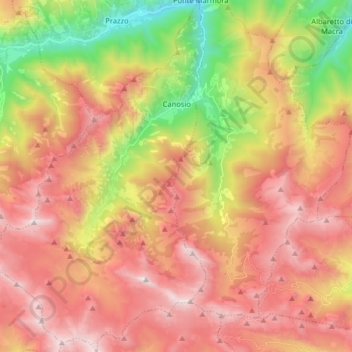
Name: Canosio topographic map, elevation, terrain.
Location: Canosio, Cuneo, Piedmont, Italy (44.37483 6.99054 44.48955 7.09592)
Average elevation: 1,975 m
Minimum elevation: 956 m
Maximum elevation: 2,815 m
Other topographic maps
Click on a map to view its topography, its elevation and its terrain.
Mont Vallonnet Nord / Cima las Blancias
Italy > Piedmont > Cuneo > Pietraporzio
Average elevation: 2,522 m