
Edgars Creek topographic map
Interactive map
Click on the map to display elevation.
About this map
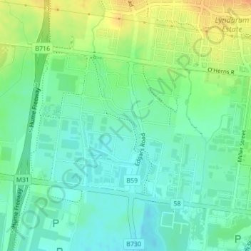
Name: Edgars Creek topographic map, elevation, terrain.
Location: Edgars Creek, City of Whittlesea, 维多利亚州, 3076, 澳大利亚 (-37.64988 145.00053 -37.63496 145.00800)
Average elevation: 136 m
Minimum elevation: 121 m
Maximum elevation: 161 m
Other topographic maps
Click on a map to view its topography, its elevation and its terrain.
Trentham Falls
Trentham Falls, Trentham, Shire of Hepburn, 维多利亚州, 3458, 澳大利亚
Average elevation: 689 m
Dandenong District
Dandenong District, 墨爾本, City of Greater Dandenong, 维多利亚州, 澳大利亚
Average elevation: 40 m
Rutherglen
澳大利亚 > 维多利亚州 > Rutherglen
Rutherglen, Shire of Indigo, 维多利亚州, 3685, 澳大利亚
Average elevation: 158 m