
Eubigheim topographic map
Interactive map
Click on the map to display elevation.
About this map
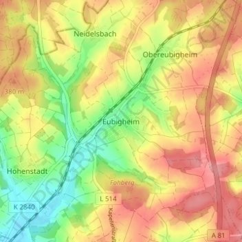
Name: Eubigheim topographic map, elevation, terrain.
Average elevation: 361 m
Minimum elevation: 304 m
Maximum elevation: 410 m
Other topographic maps
Click on a map to view its topography, its elevation and its terrain.
Schillingstadt
Deutschland > Baden-Württemberg > Main-Tauber-Kreis > Ahorn
Schillingstadt, Ahorn, Verwaltungsgemeinschaft Boxberg, Main-Tauber-Kreis, Baden-Württemberg, 74744, Deutschland
Average elevation: 365 m
Berolzheim
Deutschland > Baden-Württemberg > Main-Tauber-Kreis > Ahorn
Berolzheim, Ahorn, Verwaltungsgemeinschaft Boxberg, Main-Tauber-Kreis, Baden-Württemberg, 74744, Deutschland
Average elevation: 359 m