
Thank you for supporting this site ❤️
Make a donation
Make a donation
Odeghien topographic map
Click on the map to display elevation.
Thank you for supporting this site ❤️
Make a donation
Make a donation
About this map
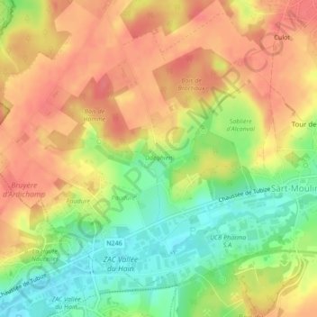
Name: Odeghien topographic map, elevation, terrain.
Average elevation: 100 m
Minimum elevation: 62 m
Maximum elevation: 129 m
Thank you for supporting this site ❤️
Make a donation
Make a donation
Other topographic maps
Click on a map to view its topography, its elevation and its terrain.
Ophain-Bois-Seigneur-Isaac
Belgique > Brabant wallon > Nivelles > Braine-l'Alleud
Average elevation: 126 m
Thank you for supporting this site ❤️
Make a donation
Make a donation
Thank you for supporting this site ❤️
Make a donation
Make a donation