Coventry topographic map
Interactive map
Click on the map to display elevation.
About this map
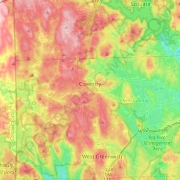
Name: Coventry topographic map, elevation, terrain.
Location: Coventry, Kent County, Rhode Island, United States (41.65605 -71.78970 41.73021 -71.53309)
Average elevation: 126 m
Minimum elevation: 47 m
Maximum elevation: 213 m
Other topographic maps
Click on a map to view its topography, its elevation and its terrain.
Anthony
United States > Rhode Island > Kent County > Coventry
Anthony, Coventry, Kent County, Rhode Island, 02816, United States
Average elevation: 71 m
East Greenwich
United States > Rhode Island > Kent County
East Greenwich, Kent County, Rhode Island, 02818, United States
Average elevation: 21 m
Apponaug
United States > Rhode Island > Kent County
Apponaug, Kent County, Rhode Island, 02886, United States
Average elevation: 23 m
Crompton
United States > Rhode Island > Kent County > West Warwick
Crompton, West Warwick, Kent County, Rhode Island, 02893, United States
Average elevation: 63 m
West Greenwich
United States > Rhode Island > Kent County > West Greenwich
West Greenwich, Kent County, Rhode Island, 02817, United States
Average elevation: 111 m
Warwick
United States > Rhode Island > Kent County
Warwick, Kent County, Rhode Island, United States
Average elevation: 34 m