
Thank you for supporting this site ❤️
Make a donation
Make a donation
Hasty topographic map
Click on the map to display elevation.
Thank you for supporting this site ❤️
Make a donation
Make a donation
About this map
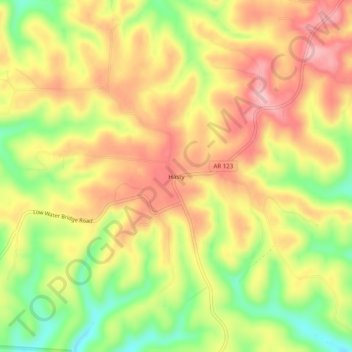
Name: Hasty topographic map, elevation, terrain.
Location: Hasty, Newton County, Arkansas, 72640, United States (35.99508 -93.06767 36.03508 -93.02767)
Average elevation: 337 m
Minimum elevation: 249 m
Maximum elevation: 405 m
Thank you for supporting this site ❤️
Make a donation
Make a donation
Other topographic maps
Click on a map to view its topography, its elevation and its terrain.