
Französisch Buchholz topographic map
Interactive map
Click on the map to display elevation.
About this map
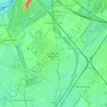
Name: Französisch Buchholz topographic map, elevation, terrain.
Location: Französisch Buchholz, Pankow, Berlin, 13127, Allemagne (52.58215 13.41197 52.64042 13.46896)
Average elevation: 51 m
Minimum elevation: 34 m
Maximum elevation: 98 m
Other topographic maps
Click on a map to view its topography, its elevation and its terrain.
Tempelhof-Schöneberg
Tempelhof-Schöneberg, Berlin, Allemagne
Average elevation: 45 m
Charlottenburg-Wilmersdorf
Charlottenburg-Wilmersdorf, Berlin, Allemagne
Average elevation: 44 m
Blankenfelde
Blankenfelde, Pankow, Berlin, 13159, Allemagne
Average elevation: 50 m
Charlottenburg
Charlottenburg, Charlottenburg-Wilmersdorf, Berlin, Allemagne
Average elevation: 41 m
Schöneberg
Schöneberg, Tempelhof-Schöneberg, Berlin, Allemagne
Average elevation: 46 m
Müggelheim
Allemagne > Berlin > Karolinenhof
Müggelheim, Treptow-Köpenick, Karolinenhof, Berlin, Allemagne
Average elevation: 38 m