
Rangitoto Island topographic map
Interactive map
Click on the map to display elevation.
About this map
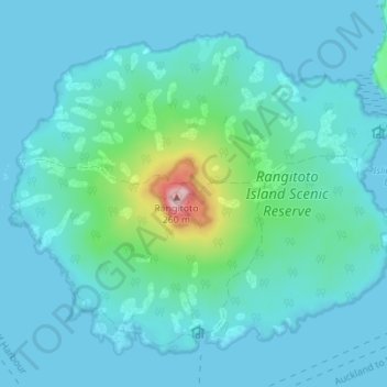
Name: Rangitoto Island topographic map, elevation, terrain.
Average elevation: 30 m
Minimum elevation: 0 m
Maximum elevation: 239 m
Other topographic maps
Click on a map to view its topography, its elevation and its terrain.
Browns Island (Motukorea)
New Zealand > Auckland > Waiheke
Browns Island (Motukorea), Waiheke, Auckland, New Zealand
Average elevation: 1 m
Waiheke Island
New Zealand > Auckland > Waiheke
Waiheke Island, Waiheke, Auckland, New Zealand
Average elevation: 16 m