
Make a donation
Wallonia topographic map
Click on the map to display elevation.
Make a donation
Wallonia
Wallonia is landlocked, with an area of 16,901 km2 (6,526 sq mi), or 55 percent of the total area of Belgium. The Sambre and Meuse valley, from Liège (70 m (230 ft)) to Charleroi (120 m (390 ft)) is an entrenched river in a fault line which separates Middle Belgium (elevation 100–200 m (330–660 ft)) and High Belgium (200–700 m (660–2,300 ft)). This fault line corresponds to a part of the southern coast of the late London-Brabant Massif. The valley, along with Haine and Vesdre valleys form the sillon industriel, the historical centre of the Belgian coalmining and steelmaking industry, and is also called the Walloon industrial backbone. Due to their long industrial historic record, several segments of the valley have received specific names: Borinage, around Mons, le Centre, around La Louvière, the Pays noir, around Charleroi and the Basse-Sambre, near Namur.
Make a donation
About this map
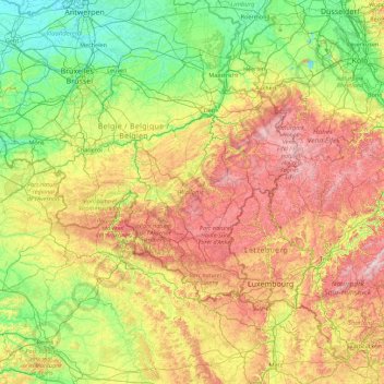
Name: Wallonia topographic map, elevation, terrain.
Location: Wallonia, Belgium (49.49698 2.84203 50.81212 6.40810)
Average elevation: 193 m
Minimum elevation: -2 m
Maximum elevation: 697 m
Make a donation
Other topographic maps
Click on a map to view its topography, its elevation and its terrain.
Battle of Waterloo
Belgium > Walloon Brabant > Waterloo
Waterloo was the decisive engagement of the Waterloo Campaign and Napoleon's last. According to Wellington, the battle was "the nearest-run thing you ever saw in your life". Napoleon abdicated four days later, and coalition forces entered Paris on 7 July. The defeat at Waterloo ended Napoleon's rule as Emperor…
Average elevation: 121 m
Make a donation
Bastogne
Belgium > Luxembourg > Bastogne > Bastogne
The municipality consists of the following districts: Bastogne, Longvilly, Noville, Villers-la-Bonne-Eau, and Wardin. The town is situated on a ridge in the Ardennes at an elevation of 510 metres (1,670 ft).
Average elevation: 505 m
Make a donation
Ardennes
Belgium > Liège > Verviers > Robertville
The region was uplifted by a mantle plume during the last few hundred thousand years, as measured from the present elevation of old river terraces.
Average elevation: 659 m
Make a donation
Woluwe Park
Belgium > Brussels-Capital > Woluwe-Saint-Pierre - Sint-Pieters-Woluwe
Average elevation: 73 m
Make a donation
Ardennes
Belgium > Liège > Verviers > Robertville
The region the Ardennes are part of has been uplifted further in the last few hundred thousand years by a mantle plume, as measured from the present elevation of old river terraces, with the largest amount of uplift concentrated in the east, where the Ardennes connect with the Eifel, where the same mantle…
Average elevation: 659 m
Make a donation
Make a donation
Make a donation
Make a donation
Make a donation
Make a donation
Make a donation
Make a donation
Make a donation
Cité du Champ de l'Ange
Belgium > Hainaut > Soignies > Braine-le-Comte > Petit-Roeulx-Lez-Braine
Average elevation: 81 m
Boonwijk
Belgium > East Flanders > Dendermonde > Dendermonde > Sint-Gillis-bij-Dendermonde
Average elevation: 4 m
Make a donation
Make a donation
Make a donation
Make a donation
Make a donation
Stavelot
Belgium > Liège > Verviers > Stavelot
Stavelot has an oceanic climate influenced by its high elevation and inland position towards a more continental type by Belgian standards. Being located at a lower elevation than neighbouring village Malmedy at the other end of the original layout of the Spa-Francorchamps race track, Stavelot is slightly…
Average elevation: 401 m
Make a donation
Make a donation
Make a donation
Make a donation
Make a donation
Make a donation
Make a donation