
Thank you for supporting this site ❤️
Make a donation
Make a donation
Halle (Westf.) topographic map
Click on the map to display elevation.
Thank you for supporting this site ❤️
Make a donation
Make a donation
About this map
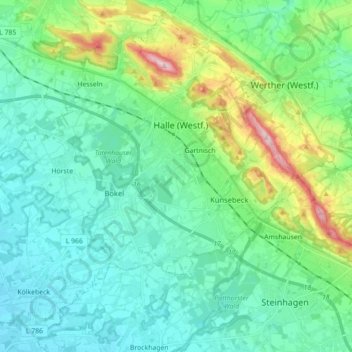
Name: Halle (Westf.) topographic map, elevation, terrain.
Average elevation: 117 m
Minimum elevation: 70 m
Maximum elevation: 304 m
Thank you for supporting this site ❤️
Make a donation
Make a donation
Other topographic maps
Click on a map to view its topography, its elevation and its terrain.
Emsquelle
Germany > North Rhine-Westphalia > Kreis Gütersloh > Schloß Holte-Stukenbrock
Average elevation: 135 m