
Thank you for supporting this site ❤️
Make a donation
Make a donation
Schönebeck (Elbe) topographic map
Click on the map to display elevation.
Thank you for supporting this site ❤️
Make a donation
Make a donation
About this map
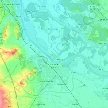
Name: Schönebeck (Elbe) topographic map, elevation, terrain.
Location: Schönebeck (Elbe), Salzlandkreis, Saxony-Anhalt, Germany (51.97492 11.65966 52.09331 11.86187)
Average elevation: 57 m
Minimum elevation: 43 m
Maximum elevation: 120 m
Thank you for supporting this site ❤️
Make a donation
Make a donation
Other topographic maps
Click on a map to view its topography, its elevation and its terrain.
Aschersleben
Germany > Saxony-Anhalt > Salzlandkreis > Aschersleben > Aschersleben
Average elevation: 139 m